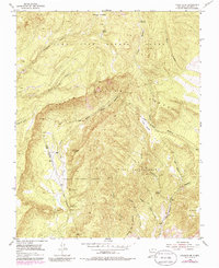
1953 Map of Canjilon SE
USGS Topo · Published 1986About this map
Historical land grants dominate this high-altitude landscape of Rio Arriba County, where the Juan Jose Lobato Grant meets the Plaza Colorada Grant and Plaza Blanca Grant. The terrain is deeply incised by drainages such as Arroyo del Cobre and Cañon Madera, which flow through the timbered reaches of the Carson National Forest. While the area is largely characterized by its complex topography and natural springs like Ojito Soldados and Ojito de las Cienaguitas, evidence of human industry is found at Las Minas de Pedro and Las Minas Jimenie. These inactive mining sites, along with a solitary Pack Trail, suggest a period of resource extraction and movement through the high country before mid-century revisions updated the landscape's features. Significant landmarks like Sierra Negra and Cerrito de la Ventana provide orientation across the diverse grant territories.
Find a feature on this map
26 named features on this map. Tap any name to fly to it.
Don’t see what you’re looking for? This feature index may not catch every label — zoom into the map to look around manually.
Map Details
Editions of this 1953 Canjilon SE Map
4 editions found
Other maps of this area

1918 · Abiquiu
USGS Topo · 1:125,000

1953 · Canones
USGS Topo · 1:24,000

1953 · Abiquiu
USGS Topo · 1:24,000

1953 · Medanales
USGS Topo · 1:24,000

1953 · Valle Grande Peak
USGS Topo · 1:24,000

1953 · Magote Peak
USGS Topo · 1:24,000

1953 · Canjilon
USGS Topo · 1:24,000

1953 · El Rito
USGS Topo · 1:24,000

1953 · Canjilon SE
USGS Topo · 1:24,000

1953 · Ghost Ranch
USGS Topo · 1:24,000