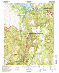
1995 Map of Canones
USGS Topo · Published 1998About this map
Juan Bautista Valdez Grant and the Piedra Lumbre Grant intersect in this landscape of high mesas and deep arroyos, reflecting the complex land-grant history of Rio Arriba County. The settlement of Cañones serves as a focal point, anchored by the Capilla de San Miguel and the nearby San Miguel (Cem). These features, alongside the Salazar Ranch, illustrate the enduring residential and agricultural patterns of the region.
Find a feature on this map
44 named features on this map. Tap any name to fly to it.
Don’t see what you’re looking for? This feature index may not catch every label — zoom into the map to look around manually.
Map Details
Editions of this 1995 Canones Map
This is the sole edition of this map. No revisions or reprints were ever made.
Other maps of this area

1909 · Gallina
USGS Topo · 1:125,000

1918 · Abiquiu
USGS Topo · 1:125,000

1953 · Canones
USGS Topo · 1:24,000

1953 · Cerro Del Grant
USGS Topo · 1:24,000

1953 · Abiquiu
USGS Topo · 1:24,000

1953 · Vallecitos
USGS Topo · 1:24,000

1953 · Polvadera Peak
USGS Topo · 1:24,000

1953 · Echo Ampitheater
USGS Topo · 1:24,000

1953 · Canjilon SE
USGS Topo · 1:24,000

1953 · Youngsville
USGS Topo · 1:24,000