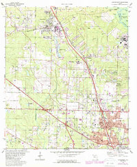
1978 Map of Cantonment
USGS Topo · Published 1987About this map
Cantonment and Gonzalez anchor this detailed study of the Florida panhandle just north of Pensacola during the late 1970s and 1980s. The landscape is defined by the heavy presence of the Burlington Northern and CSX railroads, which service the industrial corridor along the Escambia R. Large-scale utility and manufacturing footprints are evident through numerous claypits and extensive industrial waste ponds. These industrial features sit adjacent to established community landmarks like Ransom Sch and Tate Sch, illustrating the intersection of postwar residential growth and regional production.
Find a feature on this map
46 named features on this map. Tap any name to fly to it.
Don’t see what you’re looking for? This feature index may not catch every label — zoom into the map to look around manually.
Map Details
Editions of this 1978 Cantonment Map
3 editions found
Other maps of this area

1920 · Milton
USGS Topo · 1:62,500

1921 · Pensacola
USGS Topo · 1:62,500

1921 · Fort Barrancas
USGS Topo · 1:62,500

1921 · Muscogee
USGS Topo · 1:62,500

1941 · Fort Barrancas
USGS Topo · 1:62,500

1941 · Muscogee
USGS Topo · 1:62,500

1941 · Pensacola
USGS Topo · 1:62,500

1941 · Milton
USGS Topo · 1:62,500

1942 · Pensacola
USGS Topo · 1:62,500

1943 · Muscogee
USGS Topo · 1:62,500