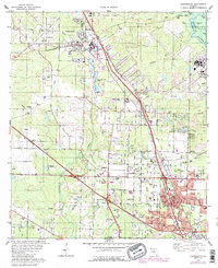
1978 Map of Cantonment
USGS Topo · Published 1987About this map
The Escambia River corridor defines the eastern boundary of this landscape, where oxbows like Waldorf Lake and Boone Lake surround Brosnaham Island. This late-1970s survey, with updates from the mid-1980s, reveals a transitional zone between industrial operations and growing residential pockets. The Burlington Northern and CSX railroads facilitate heavy industry, evidenced by the numerous claypits and large industrial waste ponds near Cantonment. Small communities like Farm Hill, Gonzalez, and Ensley are established alongside a network of local institutions, including Ransom Sch and several country churches. To the south, the U S Naval Reservation and landmarks like the Langley-Bell 4-H Center point to the area's diverse land use, while cemeteries such as Santa Marie Cem Ch and Jordan Cem offer vital markers for genealogical research.
Find a feature on this map
61 named features on this map. Tap any name to fly to it.
Don’t see what you’re looking for? This feature index may not catch every label — zoom into the map to look around manually.
Map Details
Editions of this 1978 Cantonment Map
3 editions found
Other maps of this area

1920 · Milton
USGS Topo · 1:62,500

1921 · Pensacola
USGS Topo · 1:62,500

1921 · Fort Barrancas
USGS Topo · 1:62,500

1921 · Muscogee
USGS Topo · 1:62,500

1941 · Fort Barrancas
USGS Topo · 1:62,500

1941 · Muscogee
USGS Topo · 1:62,500

1941 · Pensacola
USGS Topo · 1:62,500

1941 · Milton
USGS Topo · 1:62,500

1942 · Pensacola
USGS Topo · 1:62,500

1943 · Muscogee
USGS Topo · 1:62,500