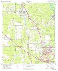
1978 Map of Cantonment
USGS Topo · Published 1978About this map
The Escambia River defines the eastern boundary of this landscape, winding past Brosnaham Island and a series of backwater lakes like Becks Lake and Boone Lake. Further west, the industrial and residential growth of the late 1970s is evident in the settlements of Cantonment, Ensley, and Olive. The area is heavily marked by the infrastructure of the era, including multiple industrial waste ponds and numerous claypits scattered throughout the terrain. Transportation networks are dominated by the Louisville and Nashville and St Louis-San Francisco railroads, which converge near the U S Naval Reservation. For genealogists, the map preserves the locations of rural landmarks such as Santa Marie Cem and Carr Chapel, alongside local institutions like Ransom Sch and the Langley-Bell 4-H Center.
Find a feature on this map
66 named features on this map. Tap any name to fly to it.
Don’t see what you’re looking for? This feature index may not catch every label — zoom into the map to look around manually.
Map Details
Editions of this 1978 Cantonment Map
3 editions found
Other maps of this area

1920 · Milton
USGS Topo · 1:62,500

1921 · Pensacola
USGS Topo · 1:62,500

1921 · Fort Barrancas
USGS Topo · 1:62,500

1921 · Muscogee
USGS Topo · 1:62,500

1941 · Fort Barrancas
USGS Topo · 1:62,500

1941 · Muscogee
USGS Topo · 1:62,500

1941 · Pensacola
USGS Topo · 1:62,500

1941 · Milton
USGS Topo · 1:62,500

1942 · Pensacola
USGS Topo · 1:62,500

1943 · Muscogee
USGS Topo · 1:62,500