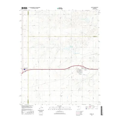
2016 Map of Canute
USGS Topo · Published 2016About this map
Canute and the eastern edge of Elk City define this western Oklahoma landscape, where the legacy of the mother road and local agriculture intersect. The path of Old US Hwy 66 remains a prominent fixture, running parallel to the modern interstate and the street grid of Canute, which includes local thoroughfares like Scheidel Ave and Broadway. The terrain is shaped by a series of water management projects, including Soldier Cr-Watershed Site 5 Reservoir and Soldier Cr Watershed Site 3 Reservoir, which provide essential catchments for the drainages of Oak Creek and Turkey Creek. For genealogists and local historians, the map preserves the locations of three distinct burial grounds: Holy Family Cem, Edwardsville Cem, and Hebron Cem, each serving as a anchor for the rural communities spanning the borders of Beckham, Custer, and Washita counties.
Find a feature on this map
33 named features on this map. Tap any name to fly to it.
Don’t see what you’re looking for? This feature index may not catch every label — zoom into the map to look around manually.
Map Details
Editions of this 2016 Canute Map
This is the sole edition of this map. No revisions or reprints were ever made.
Other maps of this area

1955 · Clinton
USGS Topo · 1:250,000

1957 · Clinton
USGS Topo · 1:250,000

1957 · Butler
USGS Topo · 1:62,500

1957 · Dill City
USGS Topo · 1:62,500

1960 · Hammon
USGS Topo · 1:62,500

1961 · Elk City
USGS Topo · 1:62,500

1976 · Butler SW
USGS Topo · 1:24,000

1976 · Dill City NE
USGS Topo · 1:24,000
1983 · Foss Dam
USGS Topo · 1:24,000
1983 · Foss
USGS Topo · 1:24,000