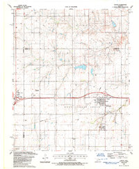
1987 Map of Canute
USGS Topo · Published 1987About this map
Canute and the eastern edge of Elk City are the primary focal points of this 1980s Western Oklahoma study, situated within a landscape defined by the local energy economy. The extensive Gas Field dominates the terrain, marked by numerous Gas Wells and a Compressor Station that signal the region's industrial character. Transportation and utility networks are prominent, including the Farmrail line and multiple pipelines that cut across the section lines. The rural community structure is visible through traditional landmarks such as St Matthews Ch and several burial grounds, including Holy Family Cem, Edwardsville Cem, and Hebron Cem. Drainage patterns are established by Turkey Creek and Oak Creek, which meander through a grid of agricultural land and occasional Trailer Parks near the larger settlements.
Find a feature on this map
20 named features on this map. Tap any name to fly to it.
Don’t see what you’re looking for? This feature index may not catch every label — zoom into the map to look around manually.
Map Details
Editions of this 1987 Canute Map
This is the sole edition of this map. No revisions or reprints were ever made.
Other maps of this area

1955 · Clinton
USGS Topo · 1:250,000

1957 · Clinton
USGS Topo · 1:250,000

1957 · Butler
USGS Topo · 1:62,500

1957 · Dill City
USGS Topo · 1:62,500

1960 · Hammon
USGS Topo · 1:62,500

1961 · Elk City
USGS Topo · 1:62,500

1976 · Butler SW
USGS Topo · 1:24,000

1976 · Dill City NE
USGS Topo · 1:24,000
1983 · Foss Dam
USGS Topo · 1:24,000
1983 · Foss
USGS Topo · 1:24,000