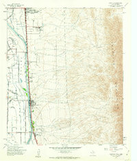
1955 Map of Canutillo
USGS Topo · Published 1962About this map
The Mesilla Valley serves as a stark corridor of agricultural and civil development between the high desert of the Franklin Mountains and the meandering path of the Rio Grande. This mid-century landscape is defined by an intricate network of irrigation and drainage systems, such as the Anthony Drain and Canutillo Lateral, which support the settlements of Anthony, La Tuna, and Canutillo. The presence of the Federal Correctional Institution and the Atchison Topeka and Santa Fe railroad line highlights the area's role as a transit and institutional hub along the New Mexico and Texas border. Local life is anchored by landmarks like Mt Zion Ch and river crossings including the Vinton Bridge and Borderland Bridge.
Find a feature on this map
29 named features on this map. Tap any name to fly to it.
Don’t see what you’re looking for? This feature index may not catch every label — zoom into the map to look around manually.
Map Details
Editions of this 1955 Canutillo Map
4 editions found
Other maps of this area

1891 · Las Cruces
USGS Topo · 1:125,000

1893 · Las Cruces
USGS Topo · 1:125,000

1896 · El Paso
USGS Topo · 1:125,000

1908 · El Paso
USGS Topo · 1:125,000

1917 · Canutillo
USGS Topo · 1:62,500

1919 · Canutillo
USGS Topo · 1:62,500

1940 · Newman
USGS Topo · 1:62,500

1941 · El Paso
USGS Topo · 1:31,680

1942 · Fort Bliss
USGS Topo · 1:62,500

1943 · La Mesa
USGS Topo · 1:62,500