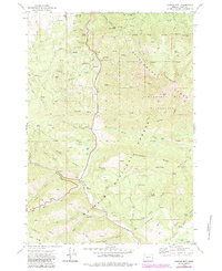
1972 Map of Canyon Mtn
USGS Topo · Published 1984About this map
Malheur National Forest dominates this topographic study of the Strawberry Range, documenting a landscape defined by high-altitude mining and timber resources in the early 1970s. The map illustrates the region's industrial footprint through dredge tailings along the upper reaches of Canyon Creek and a network of remote workings including the Miller Mtn Mine, Great Northern Mine, and the Iron King Mine.
Find a feature on this map
76 named features on this map. Tap any name to fly to it.
Don’t see what you’re looking for? This feature index may not catch every label — zoom into the map to look around manually.
Map Details
Editions of this 1972 Canyon Mtn Map
3 editions found
Other maps of this area

1940 · Mount Vernon
USGS Topo · 1:62,500

1940 · John Day
USGS Topo · 1:62,500

1943 · John Day
USGS Topo · 1:62,500

1943 · Mount Vernon
USGS Topo · 1:62,500

1955 · Canyon City
USGS Topo · 1:250,000

1959 · Canyon City
USGS Topo · 1:250,000

1961 · Logdell
USGS Topo · 1:62,500

1961 · Seneca
USGS Topo · 1:62,500

1972 · John Day
USGS Topo · 1:24,000

1972 · Canyon Mtn
USGS Topo · 1:24,000