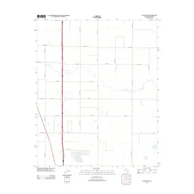
2012 Map of Canyon SE
USGS Topo · Published 2012About this map
The High Plains landscape of Randall County is defined by a rigid grid of rural corridors and the passage of I 27, which bisects the territory from north to south. This area, surveyed by the U.S. Geological Survey in 2012, illustrates the intersection of modern transportation infrastructure and the natural drainage of the Llano Estacado. The ephemeral path of S Cita Cr cuts across the geometric road network, providing a rare topographical variation in an otherwise planar expanse of agricultural and ranch land. Local connectivity is maintained through named thoroughfares such as Lawrence Rd and Dowlen Rd, while regional access is facilitated by Ranch Road 1705 and W Fm 285. The map serves as a detailed record of the township and range survey system, where section lines are solidified into long, straight roads like Osage St and Pipeline Rd.
Find a feature on this map
18 named features on this map. Tap any name to fly to it.
Don’t see what you’re looking for? This feature index may not catch every label — zoom into the map to look around manually.
Map Details
Editions of this 2012 Canyon SE Map
This is the sole edition of this map. No revisions or reprints were ever made.
Other maps of this area

1954 · Plainview
USGS Topo · 1:250,000

1956 · Fortress Cliff
USGS Topo · 1:24,000

1958 · Plainview
USGS Topo · 1:250,000

1960 · Canyon
USGS Topo · 1:62,500

1960 · Wayside
USGS Topo · 1:62,500

1965 · Happy
USGS Topo · 1:24,000

1966 · Tulia NW
USGS Topo · 1:24,000

1969 · Tule Lake NW
USGS Topo · 1:24,000
1984 · Canyon
USGS Topo · 1:24,000
1984 · Ogg
USGS Topo · 1:24,000