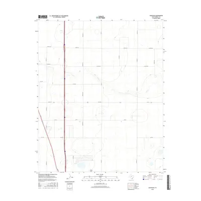
2016 Map of Canyon SE
USGS Topo · Published 2016About this map
S Cita Cr meanders across this High Plains landscape, a terrain defined by subtle drainage patterns and a strictly organized grid of rural corridors. The map highlights the transition from traditional ranchland and open fields toward a more structured transportation network southeast of Canyon. Significant local thoroughfares like S Georgia St and S Eastern St segment the territory, while landmarks such as Happy Draw provide the primary relief in the otherwise level topography. The survey details a network of named county routes including Lawrence Rd, W Dowlen Rd, and Wayside Rd, reflecting the area's development for both agricultural and residential use during the mid-2010s. This period captures the expanding outskirts where residential streets like Rawley begin to interface with traditional farm-to-market routes like FM 1705.
Find a feature on this map
21 named features on this map. Tap any name to fly to it.
Don’t see what you’re looking for? This feature index may not catch every label — zoom into the map to look around manually.
Map Details
Editions of this 2016 Canyon SE Map
This is the sole edition of this map. No revisions or reprints were ever made.
Other maps of this area

1954 · Plainview
USGS Topo · 1:250,000

1956 · Fortress Cliff
USGS Topo · 1:24,000

1958 · Plainview
USGS Topo · 1:250,000

1960 · Canyon
USGS Topo · 1:62,500

1960 · Wayside
USGS Topo · 1:62,500

1965 · Happy
USGS Topo · 1:24,000

1966 · Tulia NW
USGS Topo · 1:24,000

1969 · Tule Lake NW
USGS Topo · 1:24,000
1984 · Canyon
USGS Topo · 1:24,000
1984 · Ogg
USGS Topo · 1:24,000