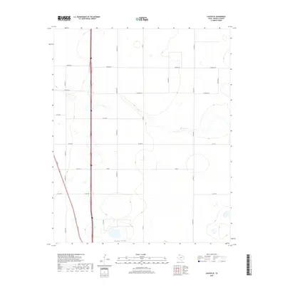
2019 Map of Canyon SE
USGS Topo · Published 2019About this map
S Cita Cr meanders across this High Plains landscape, cutting a visible path through the agricultural grid of Randall County. This area represents a transition between open range and organized rural development, where the land is partitioned by a meticulous network of roads like Lawrence Rd, Wayside Rd, and Co Rd 388. The presence of several ephemeral wetland features and the named waterway of Happy Draw in the south indicate the vital role of drainage in this semi-arid environment. Interstate and farm-to-market infrastructure, including FM 1705 and E FM 285, connect these rural sections to larger regional hubs. Geographers and local historians can observe the systematic layout of the Panhandle, with property boundaries and access routes such as S Georgia St and S Eastern St reflecting the region's late 20th and early 21st-century growth patterns.
Find a feature on this map
21 named features on this map. Tap any name to fly to it.
Don’t see what you’re looking for? This feature index may not catch every label — zoom into the map to look around manually.
Map Details
Editions of this 2019 Canyon SE Map
This is the sole edition of this map. No revisions or reprints were ever made.
Other maps of this area

1954 · Plainview
USGS Topo · 1:250,000

1956 · Fortress Cliff
USGS Topo · 1:24,000

1958 · Plainview
USGS Topo · 1:250,000

1960 · Canyon
USGS Topo · 1:62,500

1960 · Wayside
USGS Topo · 1:62,500

1965 · Happy
USGS Topo · 1:24,000

1966 · Tulia NW
USGS Topo · 1:24,000

1969 · Tule Lake NW
USGS Topo · 1:24,000
1984 · Canyon
USGS Topo · 1:24,000
1984 · Ogg
USGS Topo · 1:24,000