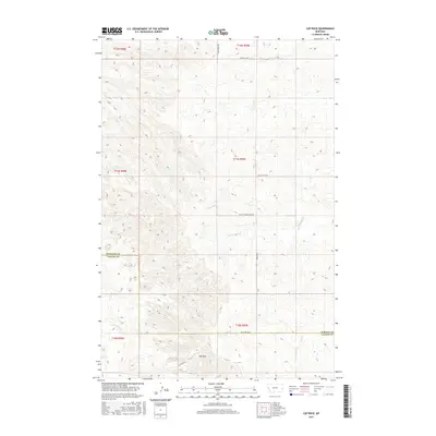
2017 Map of Cap Rock
USGS Topo · Published 2017About this map
Cap Rock stands as a focal point in this portion of the Montana plains, situated along the county line where Wibaux Co and Fallon Co meet. The landscape is defined by a dendritic network of seasonal drainages, including the Rattlesnake Cr and the N Fork Cabin Cr, which carve through the high prairie. The map documents a sparsely populated ranching or agricultural environment where movement is dictated by a grid of local routes such as High Point Rd and Beacon Hill Rd. The orientation of these roads and the inclusion of the Cap Rock Rd suggest a landscape primarily shaped by land division and water access. Significant topographical features like Cedar Cr and Ash Cr provide the primary geographical markers in an otherwise open terrain.
Find a feature on this map
19 named features on this map. Tap any name to fly to it.
Don’t see what you’re looking for? This feature index may not catch every label — zoom into the map to look around manually.
Map Details
Editions of this 2017 Cap Rock Map
This is the sole edition of this map. No revisions or reprints were ever made.
Other maps of this area

1953 · Miles City
USGS Topo · 1:250,000

1957 · Miles City
USGS Topo · 1:250,000

1958 · Miles City
USGS Topo · 1:250,000

1981 · Lawrence Creek East
USGS Topo · 1:24,000

1981 · Cap Rock
USGS Topo · 1:24,000

1981 · Rocking Chair Butte
USGS Topo · 1:24,000
1981 · Shell Butte
USGS Topo · 1:24,000
1981 · Rush Hall Reservoir
USGS Topo · 1:24,000
1981 · Carlyle NW
USGS Topo · 1:24,000

1981 · Wibaux
USGS Topo · 1:100,000