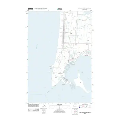
2011 Map of Cape Disappointment
USGS Topo · Published 2011About this map
Cape Disappointment serves as the focal point where the Columbia River meets the Pacific Ocean, a treacherous maritime intersection marked by both the North Head Lighthouse and the Cape Disappointment Lighthouse. This 2011 survey documents the coastal configuration of the Long Beach Peninsula, including the military grounds of Fort Canby and the organized town sites of Long Beach, Seaview, and Ilwaco. The landscape reflects a mix of maritime infrastructure and recreational development, from the Port of Ilwaco Marina and its nearby Ilwaco Port Boat Launch to the Peninsula Golf Course further north. Inland, the map details the transition from the sandy shoreline to the tidal waters of Tarlatt Slough and Parker Slough, alongside family-named agricultural sites such as Johnson Ranch and Pugh Ranch. Local genealogy is anchored by the Lone Fir Cemetery and Ilwaco Cemetery, while topographic details like McKenzie Head and Ruby Island illustrate the complex shoreline of the Columbia's mouth.
Find a feature on this map
61 named features on this map. Tap any name to fly to it.
Don’t see what you’re looking for? This feature index may not catch every label — zoom into the map to look around manually.
Map Details
Editions of this 2011 Cape Disappointment Map
This is the sole edition of this map. No revisions or reprints were ever made.
Other maps of this area

1919 · Astoria
USGS Topo · 1:62,500

1938 · Cape Disappointment
USGS Topo · 1:62,500

1938 · Fort Columbia
USGS Topo · 1:62,500

1939 · Astoria
USGS Topo · 1:62,500

1943 · Fort Columbia
USGS Topo · 1:62,500

1943 · Copalis Beach
USGS Topo · 1:250,000

1949 · Chinook
USGS Topo · 1:24,000

1949 · Ocean Park
USGS Topo · 1:24,000

1949 · Long Island
USGS Topo · 1:24,000
1949 · Cape Disappointment
USGS Topo · 1:24,000