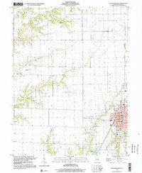
1998 Map of Carlinville West
USGS Topo · Published 2002About this map
Carlinville serves as the focal point of this Illinois survey, anchoring the eastern edge of the quadrangle with its concentrated residential blocks, Courthouse square, and the sprawling Fairground. The surrounding Macoupin County landscape is defined by the winding paths of Bear Creek and Hurricane Creek, which carve through the townships of Bird and South Palmyra. The map captures a transition in transportation, showing an Old Railroad Grade running northwest from the city, while newer local landmarks like the Harding Landing Strip and a Drive-in Theater appear on the rural outskirts.
Find a feature on this map
31 named features on this map. Tap any name to fly to it.
Don’t see what you’re looking for? This feature index may not catch every label — zoom into the map to look around manually.
Map Details
Editions of this 1998 Carlinville West Map
This is the sole edition of this map. No revisions or reprints were ever made.
Other maps of this area

1912 · Gillespie
USGS Topo · 1:62,500

1915 · Gillespie
USGS Topo · 1:62,500

1923 · Carlinville
USGS Topo · 1:48,000

1925 · Carlinville
USGS Topo · 1:62,500

1925 · Brighton
USGS Topo · 1:62,500

1928 · Brighton
USGS Topo · 1:62,500

1931 · Carlinville
USGS Topo · 1:62,500

1932 · Greenfield
USGS Topo · 1:62,500

1948 · Quincy
USGS Topo · 1:250,000

1956 · Quincy
USGS Topo · 1:250,000