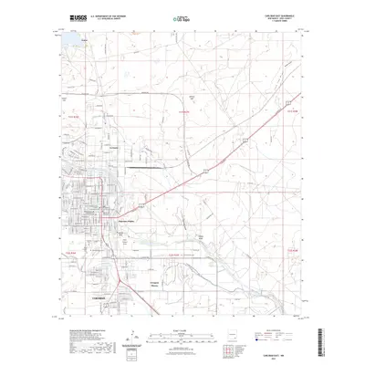
2023 Map of Carlsbad East
USGS Topo · Published 2023About this map
Carlsbad serves as the focal point of this Eastern New Mexico survey, illustrating the complex intersection of urban expansion and desert hydrology. The landscape is defined by the winding course of the Pecos River, which is supplemented by the artificial irrigation of the East Canal. This water management system supports established residential areas like La Huerta and Hagerman Heights, contrasting with the surrounding arid terrain marked by features such as Wildcat Bluff and Telltale Bluffs.
Find a feature on this map
92 named features on this map. Tap any name to fly to it.
Don’t see what you’re looking for? This feature index may not catch every label — zoom into the map to look around manually.
Map Details
Editions of this 2023 Carlsbad East Map
This is the sole edition of this map. No revisions or reprints were ever made.
Other maps of this area

1939 · Carlsbad
USGS Topo · 1:62,500

1943 · Carlsbad
USGS Topo · 1:62,500

1943 · Oil City
USGS Topo · 1:62,500

1943 · West Carlsbad
USGS Topo · 1:62,500

1945 · West Carlsbad
USGS Topo · 1:62,500

1954 · Carlsbad
USGS Topo · 1:250,000

1955 · Lake Mc Millan South
USGS Topo · 1:24,000

1958 · Carlsbad
USGS Topo · 1:250,000

1978 · Artesia
USGS Topo · 1:100,000
1979 · Carlsbad
USGS Topo · 1:100,000