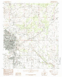
1985 Map of Carlsbad East
USGS Topo · Published 1985About this map
Carlsbad and its northern neighbors, La Huerta and Hagerman Heights, occupy the western banks of the Pecos River in this mid-1980s record of New Mexico's high desert. The landscape is defined by the complex water infrastructure necessary for arid-land agriculture and industry, featuring the massive Lake Avalon reservoir, the East Canal, and an elevated Aqueduct. The eastern half of the map reveals the extensive Carlsbad Oil Field, where numerous drills and service roads crisscross the terrain near Telltale Bluffs. Transport and industry are central to the area's development, evidenced by the Atchison Topeka and Santa Fe railroad line and a local refinery. From the residential streets of San Jose to the industrial activity of the oil fields, the map captures a pivotal period of resource extraction and community growth.
Find a feature on this map
34 named features on this map. Tap any name to fly to it.
Don’t see what you’re looking for? This feature index may not catch every label — zoom into the map to look around manually.
Map Details
Editions of this 1985 Carlsbad East Map
This is the sole edition of this map. No revisions or reprints were ever made.
Other maps of this area

1939 · Carlsbad
USGS Topo · 1:62,500

1943 · Carlsbad
USGS Topo · 1:62,500

1943 · Oil City
USGS Topo · 1:62,500

1943 · West Carlsbad
USGS Topo · 1:62,500

1945 · West Carlsbad
USGS Topo · 1:62,500

1954 · Carlsbad
USGS Topo · 1:250,000

1955 · Lake Mc Millan South
USGS Topo · 1:24,000

1958 · Carlsbad
USGS Topo · 1:250,000

1978 · Artesia
USGS Topo · 1:100,000
1979 · Carlsbad
USGS Topo · 1:100,000