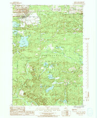
1986 Map of Carney Lake
USGS Topo · Published 1992About this map
Copper Country State Forest dominates this section of the Upper Peninsula, where the landscape is defined by the intersection of industrial mining history and dense woodlands. The northern reach around Metropolitan and Sundholm shows evidence of heavy resource extraction, notably the Mine Dump (Strippings) and multiple Tailings Ponds that mark the terrain. These features stand in contrast to the numerous pristine water bodies managed by the Michigan Department of Natural Resources, such as Carney Lake and Crystal Lake. Drainage is provided by a network of waterways including the West Branch Sturgeon River and Pine Creek. In the southern portion of the quadrangle, recreational hubs like the Boat Ramp Campground at Rock Lake illustrate the area's transition toward a wilderness and sport-focused economy in the mid-1980s.
Find a feature on this map
37 named features on this map. Tap any name to fly to it.
Don’t see what you’re looking for? This feature index may not catch every label — zoom into the map to look around manually.
Map Details
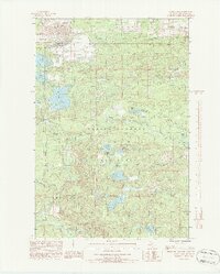
Editions of this 1986 Carney Lake Map
2 editions found
Other maps of this area

1899 · Sagola
USGS Topo · 1:62,500

1939 · Iron Mountain
USGS Topo · 1:48,000

1941 · Iron Mountain
USGS Topo · 1:48,000

1947 · Iron Mountain
USGS Topo · 1:48,000

1954 · Iron Mountain
USGS Topo · 1:250,000

1954 · Escanaba
USGS Topo · 1:250,000

1955 · Norway
USGS Topo · 1:24,000

1955 · Vulcan
USGS Topo · 1:24,000

1955 · Norway
USGS Topo · 1:62,500
1955 · Randville
USGS Topo · 1:24,000