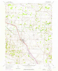
1958 Map of Carroll
USGS Topo · Published 1976About this map
The village of Carroll serves as a central hub on this mid-century survey, where the Chesapeake and Ohio and Penn Central railroads intersect amidst a landscape defined by its vanished industrial waterways. The presence of the Ohio Canal (Abandoned) and the Chesapeake and Ohio Canal (Abandoned) tracing the path of Walnut Creek highlights the era when towpaths were giving way to rail and road.
Find a feature on this map
34 named features on this map. Tap any name to fly to it.
Don’t see what you’re looking for? This feature index may not catch every label — zoom into the map to look around manually.
Map Details
Editions of this 1958 Carroll Map
4 editions found

Other maps of this area

1907 · Lancaster
USGS Topo · 1:62,500

1907 · Thurston
USGS Topo · 1:62,500

1909 · Lancaster
USGS Topo · 1:62,500

1909 · Thurston
USGS Topo · 1:62,500

1914 · Circleville
USGS Topo · 1:62,500

1925 · East Columbus
USGS Topo · 1:62,500

1943 · Circleville
USGS Topo · 1:62,500

1943 · East Columbus
USGS Topo · 1:62,500

1947 · Columbus
USGS Topo · 1:250,000
1955 · Canal Winchester
USGS Topo · 1:24,000