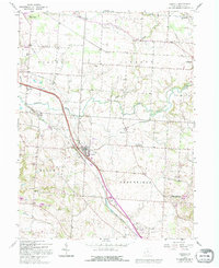
1958 Map of Carroll
USGS Topo · Published 1995About this map
The Ohio Canal (Abandoned) and the Ohio Railroad Grade (Abandoned) slice through this Fairfield County landscape, marking a legacy of nineteenth-century transportation infrastructure that helped shape local development. Centered on the village of Carroll, the area shows a transition from historical canal-era settlements like Havensport and Lockville to mid-twentieth-century additions such as the Anchor Hocking Airport and a Drive-in Theater. Rural life is anchored by family-named landmarks and places of worship, including the Wildermuth Memorial Ch and Betzer Cem. The terrain is drained by the winding Walnut Creek and Poplar Creek, while the Greenfeild Dam State Wildlife Area occupies the southeast, preserving open ground amidst the townships of Violet, Liberty, Bloom, and Greenfield.
Find a feature on this map
31 named features on this map. Tap any name to fly to it.
Don’t see what you’re looking for? This feature index may not catch every label — zoom into the map to look around manually.
Map Details
Editions of this 1958 Carroll Map
4 editions found

Other maps of this area

1907 · Lancaster
USGS Topo · 1:62,500

1907 · Thurston
USGS Topo · 1:62,500

1909 · Lancaster
USGS Topo · 1:62,500

1909 · Thurston
USGS Topo · 1:62,500

1914 · Circleville
USGS Topo · 1:62,500

1925 · East Columbus
USGS Topo · 1:62,500

1943 · Circleville
USGS Topo · 1:62,500

1943 · East Columbus
USGS Topo · 1:62,500

1947 · Columbus
USGS Topo · 1:250,000
1955 · Canal Winchester
USGS Topo · 1:24,000