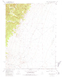
1969 Map of Carroll Summit NE
USGS Topo · Published 1981About this map
The Old Overland Road cuts through the southern reaches of this high-desert landscape, tracing a historic path of western migration across the Lander County terrain. The settlement at Smith sits near the base of the Desatoya Mts, where the mountains meet the wide expanse of the Smith Creek Valley. This 1969 survey captures an environment defined by its scarce but vital water sources, including Stoker Spring No 1, Porter Spring, and Twin Springs. The topography is marked by significant elevation changes, from the heights of Porter Canyon and its South Fork down to the valley floor. A network of primitive transit routes, labeled simply as Trail or Jeep Trail, connects these remote points, reflecting the functional and isolated nature of the Great Basin at this time.
Find a feature on this map
18 named features on this map. Tap any name to fly to it.
Don’t see what you’re looking for? This feature index may not catch every label — zoom into the map to look around manually.
Map Details
Editions of this 1969 Carroll Summit NE Map
2 editions found
Other maps of this area

1955 · Millett
USGS Topo · 1:250,000

1959 · Millett
USGS Topo · 1:250,000

1966 · Edwards Creek Valley
USGS Topo · 1:62,500

1969 · Mount Airy
USGS Topo · 1:24,000

1969 · Emigrant Peak
USGS Topo · 1:24,000

1969 · Carroll Summit NE
USGS Topo · 1:24,000

1969 · Carroll Summit
USGS Topo · 1:24,000

1969 · Basque Summit
USGS Topo · 1:24,000

1969 · Iron Mountain
USGS Topo · 1:24,000
1969 · Carroll Summit SE
USGS Topo · 1:24,000