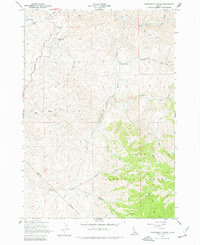
1957 Map of Cartwright Canyon
USGS Topo · Published 1977About this map
Dobson Ranch sits near the center of this 1950s landscape, serving as a primary marker of settlement within the rugged canyon systems north of Boise. The terrain is defined by the drainage of Harris Creek and Shafer Creek, which cut through the high ridges of the Boise National Forest. To the northwest, Home Lake and the prominent Bread Loaf Rock stand as notable landmarks for navigators and surveyors of the era.
Find a feature on this map
22 named features on this map. Tap any name to fly to it.
Don’t see what you’re looking for? This feature index may not catch every label — zoom into the map to look around manually.
Map Details
Editions of this 1957 Cartwright Canyon Map
4 editions found
Other maps of this area

1892 · Boise
USGS Topo · 1:125,000

1897 · Boise
USGS Topo · 1:125,000

1949 · Robie Creek
USGS Topo · 1:24,000

1953 · Eagle
USGS Topo · 1:24,000

1953 · Montour
USGS Topo · 1:62,500

1954 · Boise North
USGS Topo · 1:24,000

1954 · Boise
USGS Topo · 1:62,500

1955 · Boise
USGS Topo · 1:250,000

1957 · Cartwright Canyon
USGS Topo · 1:24,000

1957 · Horseshoe Bend
USGS Topo · 1:24,000