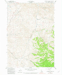
1957 Map of Cartwright Canyon
USGS Topo · Published 1982About this map
Boise National Forest dominates the southeastern terrain of this Idaho landscape, where the high ridges of the Boise and Ada County line meet. The 1957 field survey captures a region defined by its drainage basins and early ranching, centered on Cartwright Canyon and the winding Shafer Creek. Landowners and researchers can trace the historic route of the Horseshoe Bend Road as it cuts through the northwest corner near Home Lake, while specialized local landmarks like Bread Loaf Rock and Stack Rock provide distinct orientation points for those navigating the high country. Isolated outposts such as Dobson Ranch reflect the mid-century settlement pattern in these drainage valleys, linked by an extensive network of Jeep Trails that traverse the divides between Harris Creek and Spring Valley Creek.
Find a feature on this map
21 named features on this map. Tap any name to fly to it.
Don’t see what you’re looking for? This feature index may not catch every label — zoom into the map to look around manually.
Map Details
Editions of this 1957 Cartwright Canyon Map
4 editions found
Other maps of this area

1892 · Boise
USGS Topo · 1:125,000

1897 · Boise
USGS Topo · 1:125,000

1949 · Robie Creek
USGS Topo · 1:24,000

1953 · Eagle
USGS Topo · 1:24,000

1953 · Montour
USGS Topo · 1:62,500

1954 · Boise North
USGS Topo · 1:24,000

1954 · Boise
USGS Topo · 1:62,500

1955 · Boise
USGS Topo · 1:250,000

1957 · Cartwright Canyon
USGS Topo · 1:24,000

1957 · Horseshoe Bend
USGS Topo · 1:24,000