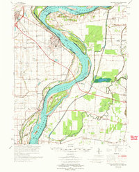
1973 Map of Caruthersville
USGS Topo · Published 1973About this map
Caruthersville serves as the focal point for this study of the Missouri Bootheel, where the Mississippi River creates a complex border with Tennessee. The landscape is defined by extensive flood control measures, including numerous levees, revetments, and drainage ditches such as Robinson Bayou Revet. This 1970s record shows the intricate river engineering around Little Prairie Bend and Linwood Bend, highlighting the series of numbered islands from Island No. 14 down to Island No. 20.
Find a feature on this map
79 named features on this map. Tap any name to fly to it.
Don’t see what you’re looking for? This feature index may not catch every label — zoom into the map to look around manually.
Map Details
Editions of this 1973 Caruthersville Map
This is the sole edition of this map. No revisions or reprints were ever made.
Other maps of this area

1925 · Reelfoot Lake
USGS Topo · 1:62,500

1939 · Reelfoot Lake
USGS Topo · 1:62,500

1939 · Portageville
USGS Topo · 1:62,500

1939 · Dyersburg
USGS Topo · 1:62,500

1939 · Hales Point
USGS Topo · 1:62,500

1939 · Caruthersville
USGS Topo · 1:62,500

1939 · Halls
USGS Topo · 1:62,500

1939 · Blytheville
USGS Topo · 1:62,500

1940 · Pascola
USGS Topo · 1:62,500

1940 · Hayti
USGS Topo · 1:62,500