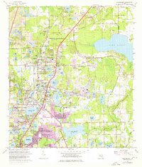
1962 Map of Casselberry
USGS Topo · Published 1976About this map
The lake-strewn corridor of Seminole County undergoes significant suburban expansion in the early 1960s, a transformation tracked by the Department of the Interior through detailed topographic updates. At the center of this landscape, Casselberry and Longwood are surrounded by a dense network of water bodies, from the sprawling Lake Jessup on the eastern edge to smaller pools like Fairy Lake and Lake Kathryn. The presence of the Seaboard Coast Line railroad and the Sanford-Orlando Kennel Club highlights the area's dual character as a transit hub and a recreational destination. Cultural landmarks such as Mt Olive Ch and Lyman High Sch serve the growing residential clusters in Altamonte Springs and Fern Park, while specialized sites like the Seminole Park Raceway and the Go-Cart Track reflect the mid-century leisure economy. Even as development encroaches, natural features like Mecca Hammock and Big Tree Park persist alongside industrial markers such as several claypits.
Find a feature on this map
111 named features on this map. Tap any name to fly to it.
Don’t see what you’re looking for? This feature index may not catch every label — zoom into the map to look around manually.
Map Details
Editions of this 1962 Casselberry Map
5 editions found
Other maps of this area

1953 · Oviedo SW
USGS Topo · 1:24,000

1955 · Orlando
USGS Topo · 1:250,000

1956 · Oviedo
USGS Topo · 1:24,000

1956 · Orlando West
USGS Topo · 1:24,000

1956 · Orlando East
USGS Topo · 1:24,000

1957 · Orlando
USGS Topo · 1:250,000

1958 · Orlando
USGS Topo · 1:250,000

1959 · Forest City
USGS Topo · 1:24,000

1962 · Orlando
USGS Topo · 1:250,000

1962 · Casselberry
USGS Topo · 1:24,000