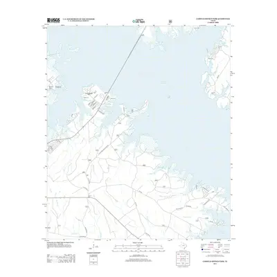
2013 Map of Cassells-Boykin Park
USGS Topo · Published 2013About this map
Sam Rayburn Reservoir dominates this landscape in Angelina County, its intricate shoreline creating numerous inlets and peninsulas that have reshaped the local geography. The map reveals how the modern recreational developments at Cassells-Boykin Park and Monterey Park Campground coexist with the area's deep-rooted pioneer history. This history is most evident in the high density of small family burial grounds that survived the reservoir's creation, such as Cassels Cem, Mott Cem, and Runnels Cem. The surrounding terrain is crisscrossed by a network of forest roads, including Texas Forest Service Rd 308, which weave through the drainage basins of Bayou Springs Cr and Little Caney Cr. The map captures a moment where old homestead sites and rural cemeteries remain as silent markers of a pre-reservoir era alongside newer lakeside access points like the Monterey Boat Ramp.
Find a feature on this map
53 named features on this map. Tap any name to fly to it.
Don’t see what you’re looking for? This feature index may not catch every label — zoom into the map to look around manually.
Map Details
Editions of this 2013 Cassells-Boykin Park Map
This is the sole edition of this map. No revisions or reprints were ever made.
Other maps of this area

1928 · Zavalla 3-c
USGS Topo · 1:24,000

1931 · Zavalla
USGS Topo · 1:62,500

1953 · Palestine
USGS Topo · 1:250,000

1957 · Palestine
USGS Topo · 1:250,000

1958 · Zavalla
USGS Topo · 1:62,500

1958 · Broaddus
USGS Topo · 1:62,500

1958 · Mc Gee Bend
USGS Topo · 1:62,500

1958 · Bronson
USGS Topo · 1:62,500
1984 · Veach
USGS Topo · 1:24,000
1984 · Harvey Creek
USGS Topo · 1:24,000