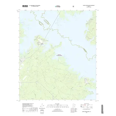
2019 Map of Cassells-Boykin Park
USGS Topo · Published 2019About this map
Sam Rayburn Reservoir dominates this East Texas landscape, where the irregular shoreline of the impoundment meets the managed timberlands of the Angelina National Forest. This modern survey reveals a region defined by outdoor recreation and quiet rural life, centered around the Cassells-Boykin Park settlement. The complex boundary lines of San Augustine, Angelina, and Nacogdoches Counties meet amidst the water, marking the historical intersection of these jurisdictions before the valley was flooded.
Find a feature on this map
51 named features on this map. Tap any name to fly to it.
Don’t see what you’re looking for? This feature index may not catch every label — zoom into the map to look around manually.
Map Details
Editions of this 2019 Cassells-Boykin Park Map
This is the sole edition of this map. No revisions or reprints were ever made.
Other maps of this area

1928 · Zavalla 3-c
USGS Topo · 1:24,000

1931 · Zavalla
USGS Topo · 1:62,500

1953 · Palestine
USGS Topo · 1:250,000

1957 · Palestine
USGS Topo · 1:250,000

1958 · Zavalla
USGS Topo · 1:62,500

1958 · Broaddus
USGS Topo · 1:62,500

1958 · Mc Gee Bend
USGS Topo · 1:62,500

1958 · Bronson
USGS Topo · 1:62,500
1984 · Veach
USGS Topo · 1:24,000
1984 · Harvey Creek
USGS Topo · 1:24,000