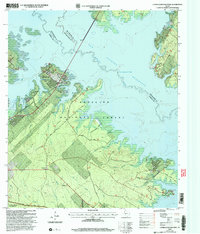
2003 Map of Cassells-Boykin Park
USGS Topo · Published 2004About this map
The Sam Angelina Rayburn Reservoir dominates this East Texas landscape, where the waters meet the dense woodlands of the Angelina National Forest. This 2003 revision reflects a region defined by recreational access and conservation, featuring the sprawling Cassells-Boykin Park and the protected Upland Island Wilderness. The map provides significant genealogical value through its documentation of rural burials, including Boykin Cem, Rayburn Cem, and Miller Cem, many of which sit on the periphery of the reservoir's fingers.
Find a feature on this map
39 named features on this map. Tap any name to fly to it.
Don’t see what you’re looking for? This feature index may not catch every label — zoom into the map to look around manually.
Map Details
Editions of this 2003 Cassells-Boykin Park Map
This is the sole edition of this map. No revisions or reprints were ever made.
Other maps of this area

1928 · Zavalla 3-c
USGS Topo · 1:24,000

1931 · Zavalla
USGS Topo · 1:62,500

1953 · Palestine
USGS Topo · 1:250,000

1957 · Palestine
USGS Topo · 1:250,000

1958 · Zavalla
USGS Topo · 1:62,500

1958 · Broaddus
USGS Topo · 1:62,500

1958 · Mc Gee Bend
USGS Topo · 1:62,500

1958 · Bronson
USGS Topo · 1:62,500
1984 · Veach
USGS Topo · 1:24,000
1984 · Harvey Creek
USGS Topo · 1:24,000