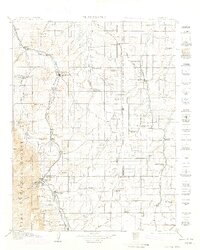
1913 Map of Castle Rock
USGS Topo · Published 1914About this map
The town of Castle Rock serves as a focal point in this 1911 survey, situated along the Atchison Topeka and Santa Fe RR and the Denver and Rio Grande RR. This pre-World War I landscape reveals a dense network of early rural education and community life, marked by numerous small schoolhouses like the Fonder School, Flintwood School, and James School. To the west, the topography rises sharply into the Pike National Forest, where features such as Dawson Butte and Storm Pk overlook the canyon country.
Find a feature on this map
91 named features on this map. Tap any name to fly to it.
Don’t see what you’re looking for? This feature index may not catch every label — zoom into the map to look around manually.
Map Details
Editions of this 1913 Castle Rock Map
5 editions found

Other maps of this area

1890 · East Denver
USGS Topo · 1:125,000

1893 · Big Springs
USGS Topo · 1:125,000

1893 · Platte Canyon
USGS Topo · 1:125,000

1893 · Colorado Springs
USGS Topo · 1:125,000

1894 · Pikes Peak
USGS Topo · 1:125,000

1894 · Castle Rock
USGS Topo · 1:125,000

1899 · West Denver
USGS Topo · 1:125,000

1901 · Pikes Peak
USGS Topo · 1:125,000

1901 · Pikes Peak
USGS Topo · 1:62,500

1909 · Colorado Springs
USGS Topo · 1:125,000