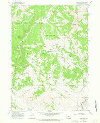
1967 Map of Castle Rock
USGS Topo · Published 1971About this map
Shoshone National Forest contains a diverse landscape of high peaks and river bottomlands, defined by the towering landmark of Castle Rock. The 1960s terrain shown here reflects a specialized land use focused on wildlife and scientific observation, evidenced by the Elk Winter Pasture (Hdqrs) and the Waynes Creek Range Experiment Station. Moving south toward the Wind River Indian Res Bdy, the landscape opens up as the East Fork Wind River flows past the Flying T Ranch. The reliance on traditional backcountry access is clear through the extensive network of pack routes, such as the Tepee Creek Trail (Pack), while a lone Landing Strip and Radio Tower mark modern transitions. Unique water features like Alkali Bog (Mud Springs) and Hole Spring punctuate the high-altitude basins and ridges.
Find a feature on this map
40 named features on this map. Tap any name to fly to it.
Don’t see what you’re looking for? This feature index may not catch every label — zoom into the map to look around manually.
Map Details
Editions of this 1967 Castle Rock Map
2 editions found
Other maps of this area

1904 · Kirwin
USGS Topo · 1:125,000

1905 · Younts Peak
USGS Topo · 1:125,000

1906 · Kirwin
USGS Topo · 1:125,000

1907 · Younts Peak
USGS Topo · 1:125,000

1955 · Thermopolis
USGS Topo · 1:250,000

1956 · Indian Point
USGS Topo · 1:24,000

1956 · Snow Lake
USGS Topo · 1:24,000

1956 · Mason Draw
USGS Topo · 1:24,000

1958 · Thermopolis
USGS Topo · 1:250,000

1962 · Thermopolis
USGS Topo · 1:250,000