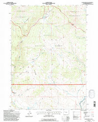
1991 Map of Castle Rock
USGS Topo · Published 1997About this map
Washakie Wilderness and the Shoshone National Forest converge in this high-altitude landscape of the Absaroka Range, dominated by the prominent Castle Rock formation. The mapping reflects a rugged terrain where water management and wildlife conservation are paramount, anchored by the East Fork Elk Winter Pasture (Hdqrs) in the southwestern quadrant. This area, updated in the early 1990s, shows a network of remote 4WD tracks and horse trails navigating complex ridges such as Finley Ridge and Diamond Ridge.
Find a feature on this map
39 named features on this map. Tap any name to fly to it.
Don’t see what you’re looking for? This feature index may not catch every label — zoom into the map to look around manually.
Map Details
Editions of this 1991 Castle Rock Map
2 editions found
Other maps of this area

1904 · Kirwin
USGS Topo · 1:125,000

1905 · Younts Peak
USGS Topo · 1:125,000

1906 · Kirwin
USGS Topo · 1:125,000

1907 · Younts Peak
USGS Topo · 1:125,000

1955 · Thermopolis
USGS Topo · 1:250,000

1956 · Indian Point
USGS Topo · 1:24,000

1956 · Snow Lake
USGS Topo · 1:24,000

1956 · Mason Draw
USGS Topo · 1:24,000

1958 · Thermopolis
USGS Topo · 1:250,000

1962 · Thermopolis
USGS Topo · 1:250,000