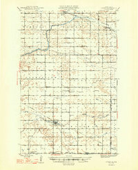
1948 Map of Cathay
USGS Topo · Published 1948About this map
The James River meanders across the northern plains of Wells County, shaping a landscape defined by small grain-hauling rail stops and scattered township schools in the mid-1940s. The village of Cathay serves as a central hub along the Minneapolis St Paul and Sault Ste Marie line, featuring the nearby Lake View Cem and a concentration of local homestead-era infrastructure. Further north, the Great Northern railroad supports the settlements of Bremen and Munster, which are surrounded by townships like Germantown and Fairview. This survey captures the rural religious fabric of the region through markers such as the Stavanger Ch, St Josephs Ch, and the Norwegian Lutheran Cem. The terrain is cut by drainage patterns of Rocky Run and Pipestem Creek, illustrating the environmental factors that dictated early 20th-century platting and road development.
Find a feature on this map
31 named features on this map. Tap any name to fly to it.
Don’t see what you’re looking for? This feature index may not catch every label — zoom into the map to look around manually.
Map Details
Editions of this 1948 Cathay Map
2 editions found
Other maps of this area

1931 · Oberon
USGS Topo · 1:62,500

1932 · Flora
USGS Topo · 1:62,500

1943 · Maddock
USGS Topo · 1:62,500

1945 · Maddock
USGS Topo · 1:62,500

1948 · New Rockford
USGS Topo · 1:62,500

1948 · Cathay
USGS Topo · 1:62,500

1948 · Fessenden
USGS Topo · 1:62,500

1948 · Carrington
USGS Topo · 1:62,500

1948 · Bremen
USGS Topo · 1:24,000

1949 · Bremen
USGS Topo · 1:24,000