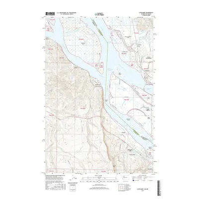
2017 Map of Cathlamet
USGS Topo · Published 2017About this map
Cathlamet sits along the northern banks of the Columbia River, serving as a central hub for the intricate network of sloughs and islands that define this stretch of the Washington-Oregon border. The landscape is a complex maze of waterways including Steamboat Slough, Elochoman Slough, and Cathlamet Channel, which isolate landmasses like Tenassillahe Island and the large, road-traversed Puget Island. Settlement patterns follow the river's edge, with Westport and Wauna on the southern shore and the former industrial site at Bradwood near Hunts Mill Point. Inland from the river, the terrain rises sharply into the Wauna Range and Nicolai Ridge. This 2017 survey documents the modern infrastructure of the region, from the Wahkiakum County Ferry crossing to the Puget Island Bridge, alongside local landmarks like Greenwood Cem and Pioneer Cem, reflecting the area's deep-rooted river-based economy and transit history.
Find a feature on this map
78 named features on this map. Tap any name to fly to it.
Don’t see what you’re looking for? This feature index may not catch every label — zoom into the map to look around manually.
Map Details
Editions of this 2017 Cathlamet Map
This is the sole edition of this map. No revisions or reprints were ever made.
Other maps of this area

1940 · Svensen
USGS Topo · 1:62,500

1940 · Brookfield
USGS Topo · 1:62,500

1941 · Skamokawa
USGS Topo · 1:62,500

1941 · Cathlamet
USGS Topo · 1:62,500

1953 · Hoquiam
USGS Topo · 1:250,000

1953 · Skamokawa
USGS Topo · 1:62,500

1953 · Cathlamet
USGS Topo · 1:62,500
1955 · Svensen
USGS Topo · 1:62,500

1955 · Grays River
USGS Topo · 1:62,500

1957 · Hoquiam
USGS Topo · 1:250,000