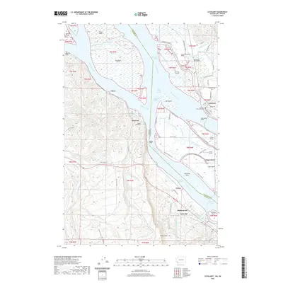
2020 Map of Cathlamet
USGS Topo · Published 2020About this map
Cathlamet sits prominently along the north bank of the Columbia River, serving as a hub for the intricate network of sloughs and islands that define the Wahkiakum County and Clatsop County border. The landscape is dominated by the river's braided channels, including the Cathlamet Channel and Clifton Channel, which carve out major landmasses like Puget Island and Tenasillahe Island. The settlement pattern follows these waterways and the rising terrain of Oklahoma Hill and Nicolai Ridge to the south.
Find a feature on this map
92 named features on this map. Tap any name to fly to it.
Don’t see what you’re looking for? This feature index may not catch every label — zoom into the map to look around manually.
Map Details
Editions of this 2020 Cathlamet Map
This is the sole edition of this map. No revisions or reprints were ever made.
Other maps of this area

1940 · Svensen
USGS Topo · 1:62,500

1940 · Brookfield
USGS Topo · 1:62,500

1941 · Skamokawa
USGS Topo · 1:62,500

1941 · Cathlamet
USGS Topo · 1:62,500

1953 · Hoquiam
USGS Topo · 1:250,000

1953 · Skamokawa
USGS Topo · 1:62,500

1953 · Cathlamet
USGS Topo · 1:62,500
1955 · Svensen
USGS Topo · 1:62,500

1955 · Grays River
USGS Topo · 1:62,500

1957 · Hoquiam
USGS Topo · 1:250,000