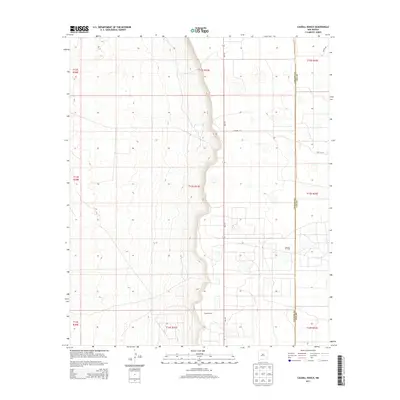
2013 Map of Caudill Ranch
USGS Topo · Published 2013About this map
Caudill Ranch sits within the high plains of Eastern New Mexico, marking a landscape defined by the boundary between Chaves and Lea Counties. This 2013 survey illustrates the modern energy and ranching economy of the region, featuring the extensive Caprock Oil Field which spans the central and eastern portions of the quadrangle. The terrain is structured by a network of local roads including Priscilla Rd, Tabitha Rd, and Co Road 157, which provide access to remote agricultural and industrial sites. State highway Nm-172 serves as the primary north-south artery, cutting through the center of the sheet and connecting these isolated ranching outposts. The map provides a clear look at the Public Land Survey System grid, detailing the townships and ranges that have organized this section of the Llano Estacado since settlement.
Find a feature on this map
16 named features on this map. Tap any name to fly to it.
Don’t see what you’re looking for? This feature index may not catch every label — zoom into the map to look around manually.
Map Details
Editions of this 2013 Caudill Ranch Map
This is the sole edition of this map. No revisions or reprints were ever made.
Other maps of this area

1954 · Brownfield
USGS Topo · 1:250,000

1958 · Brownfield
USGS Topo · 1:250,000

1962 · Brownfield
USGS Topo · 1:250,000

1973 · Culp Ranch
USGS Topo · 1:24,000
1973 · Cedar Point
USGS Topo · 1:24,000

1973 · Mescalero Point
USGS Topo · 1:24,000

1973 · Soldier Hill
USGS Topo · 1:24,000

1973 · Caudill Ranch
USGS Topo · 1:24,000

1973 · Cooper-Good Ranch
USGS Topo · 1:24,000

1973 · Dean Ranch
USGS Topo · 1:24,000