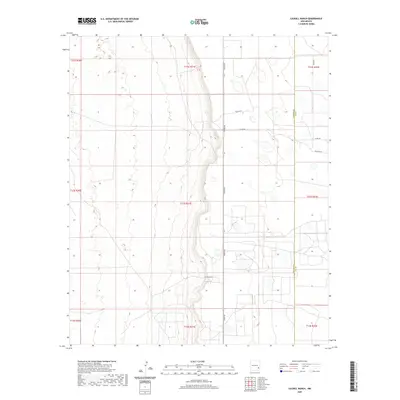
2020 Map of Caudill Ranch
USGS Topo · Published 2020About this map
Caudill Ranch sits as a primary landmark in this ranching landscape within Lea County, located along a north-south corridor defined by Tower Rd. The map illustrates the sprawling township and range system, marking the transition from Chaves County to Lea County along the Chaves Co Lea Co boundary line. This high-plains terrain is marked by a network of local access roads including Tabitha Rd, Co Rd 157, and Priscilla Rd, which serve the various ranching interests across the surveyed sections. The concentration of road labels like Grose Rd and Co Rd 159 in the northeast suggests more frequent property access points in an otherwise open environment. This survey captures the modern rural infrastructure of the Llano Estacado region, where the vastness is organized by a precise grid of sections and ranges.
Find a feature on this map
17 named features on this map. Tap any name to fly to it.
Don’t see what you’re looking for? This feature index may not catch every label — zoom into the map to look around manually.
Map Details
Editions of this 2020 Caudill Ranch Map
This is the sole edition of this map. No revisions or reprints were ever made.
Other maps of this area

1954 · Brownfield
USGS Topo · 1:250,000

1958 · Brownfield
USGS Topo · 1:250,000

1962 · Brownfield
USGS Topo · 1:250,000

1973 · Culp Ranch
USGS Topo · 1:24,000
1973 · Cedar Point
USGS Topo · 1:24,000

1973 · Mescalero Point
USGS Topo · 1:24,000

1973 · Soldier Hill
USGS Topo · 1:24,000

1973 · Caudill Ranch
USGS Topo · 1:24,000

1973 · Cooper-Good Ranch
USGS Topo · 1:24,000

1973 · Dean Ranch
USGS Topo · 1:24,000