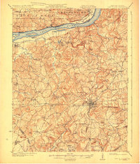
1925 Map of Cave In Rock
USGS Topo · Published 1925About this map
The Ohio River defines the northern reaches of this territory, where the historic Fords Ferry once linked the Kentucky hills to the Illinois shoreline near Battery Rock. The landscape is characterized by a dense network of early 20th-century rural infrastructure, particularly the many country schools such as Hebron School and Forest Grove School that dotted the limestone-rich terrain. In the southern portion of the map, the town of Marion serves as a hub for the Illinois Central railroad, while the surrounding countryside reveals a history of extraction at the Franklin Mines. Natural landmarks like Cave Hill Cave and the unusual drainage patterns of The Sinks highlight the unique karst topography of the region. This 1920s survey captures the area before modern modernization, showing the original placement of family-named landmarks like Crayne Knobs and Harden Knob.
Find a feature on this map
90 named features on this map. Tap any name to fly to it.
Don’t see what you’re looking for? This feature index may not catch every label — zoom into the map to look around manually.
Map Details
Editions of this 1925 Cave In Rock Map
3 editions found

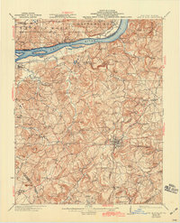
Other maps of this area

1907 · Morganfield
USGS Topo · 1:62,500

1908 · Princeton
USGS Topo · 1:62,500

1909 · Providence
USGS Topo · 1:62,500

1910 · Princeton
USGS Topo · 1:62,500

1916 · Shawneetown
USGS Topo · 1:62,500

1916 · Fords Ferry
USGS Topo · 1:62,500

1916 · Golconda
USGS Topo · 1:62,500

1916 · Equality
USGS Topo · 1:62,500

1920 · Goloonda
USGS Topo · 1:48,000

1921 · Fords Ferry
USGS Topo · 1:48,000