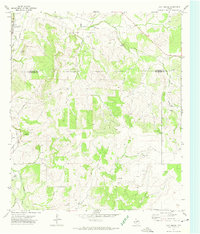
1972 Map of Cave Spring
USGS Topo · Published 1974About this map
Cave Spring and the South Concho River define this West Texas landscape along the county boundary between Tom Green and Schleicher counties. In the early 1970s, the terrain was shaped by the intermittent drainage of Dry Creek and a network of service roads connecting numerous Gravel Pits to a major Pipeline corridor. The map reveals the sparsely settled nature of the Edwards Plateau during this era, centered on the small gathering point of Oliver and a series of wells scattered across the upland pastures. The survey provides a clear view of the transition between the river's riparian edges and the arid high ground typical of the Concho Valley region before modern development further altered these rural ranchlands.
Find a feature on this map
7 named features on this map. Tap any name to fly to it.
Don’t see what you’re looking for? This feature index may not catch every label — zoom into the map to look around manually.
Map Details
Editions of this 1972 Cave Spring Map
2 editions found
Other maps of this area

1892 · San Angelo
USGS Topo · 1:125,000

1893 · Fort McKavett
USGS Topo · 1:125,000

1895 · Sherwood
USGS Topo · 1:125,000

1954 · Sonora
USGS Topo · 1:250,000

1954 · San Angelo
USGS Topo · 1:250,000

1958 · Sonora
USGS Topo · 1:250,000

1958 · San Angelo
USGS Topo · 1:250,000

1963 · Adams
USGS Topo · 1:24,000

1963 · Adams NW
USGS Topo · 1:24,000
1964 · Eldorado NE
USGS Topo · 1:24,000