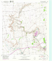
1950 Map of Cedar Bend
USGS Topo · Published 1980About this map
The Colorado River carves a winding path through this West Texas landscape, defined by dramatic topography like North Fork Canyon and Dawson Canyon. In the mid-twentieth century, the area around Colorado City was a hub of industrial activity, evidenced by the Col-Tex Refinery, a massive Tank Farm, and the busy Texas and Pacific railroad corridor. While the river remains the dominant natural feature, human engineering has reshaped the drainage with projects like Barber Reservoir and several spillways.
Find a feature on this map
41 named features on this map. Tap any name to fly to it.
Don’t see what you’re looking for? This feature index may not catch every label — zoom into the map to look around manually.
Map Details
Editions of this 1950 Cedar Bend Map
Other maps of this area

1950 · Cedar Bend
USGS Topo · 1:24,000

1950 · Lake Colorado City
USGS Topo · 1:24,000

1950 · Colorado City SE
USGS Topo · 1:24,000

1951 · Ira
USGS Topo · 1:24,000

1951 · Dunn
USGS Topo · 1:24,000

1952 · Cuthbert
USGS Topo · 1:24,000

1952 · Westbrook
USGS Topo · 1:24,000

1952 · China Grove
USGS Topo · 1:24,000

1952 · Colorado City
USGS Topo · 1:24,000

1954 · Big Spring
USGS Topo · 1:250,000