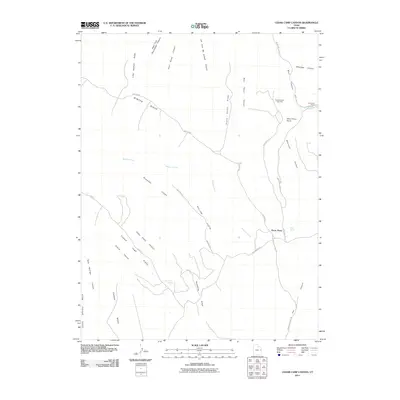
2011 Map of Cedar Camp Canyon
USGS Topo · Published 2011About this map
Tomlinson Ranch and the small settlement at Three Pines anchor this remote high-desert terrain within the Uintah Basin. The landscape is defined by deep incisions like Cedar Camp Canyon and Main Canyon, with the Fence Canyon Gas Field marking the intersection of natural topography and energy development. High ridges such as Little Asphalt Ridge and Pretty Valley Ridge provide a framework for a network of backcountry routes, including the prominent Winter Ridge Road and Book Cliff Ridge Rd. Water sources are scarce but critical to the area's history, represented by Cedar Camp Spring and Rock Springs. This survey captures the region's character as a place of vast ridgelines and hidden basins, where transit relies on topographic features like Willow Flats and Wire Fence Point.
Find a feature on this map
33 named features on this map. Tap any name to fly to it.
Don’t see what you’re looking for? This feature index may not catch every label — zoom into the map to look around manually.
Map Details
Editions of this 2011 Cedar Camp Canyon Map
This is the sole edition of this map. No revisions or reprints were ever made.
Other maps of this area

1885 · East Tavaputs
USGS Topo · 1:250,000

1956 · Grand Junction
USGS Topo · 1:250,000

1959 · Grand Junction
USGS Topo · 1:250,000

1960 · Grand Junction
USGS Topo · 1:250,000

1962 · Grand Junction
USGS Topo · 1:250,000

1963 · Tenmile Canyon
USGS Topo · 1:62,500

1964 · Grand Junction
USGS Topo · 1:250,000

1965 · Grand Junction
USGS Topo · 1:250,000

1966 · Seep Canyon
USGS Topo · 1:24,000
1966 · Wolf Point
USGS Topo · 1:24,000