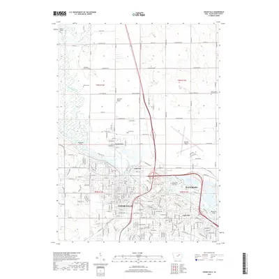
2018 Map of Cedar Falls
USGS Topo · Published 2018About this map
The Cedar Falls and Waterloo metropolitan corridor is defined by the winding course of the Cedar River and its major tributaries like Beaver Creek and Dry Run. In the late 2010s, this area shows a dense network of suburban growth and industrial infrastructure, particularly surrounding the Waterloo Regional Airport. Between the two primary cities, the George Wyth Memorial State Park preserves a significant riparian landscape of lakes and islands, including Fisher Lake and Deadmans Island. For local historians and genealogists, the map identifies several distinct neighborhood enclaves and older burial grounds, such as North Cedar, Castle Hill, and the Washington Chapel Cem. The transportation grid reveals a transition from the established street grids of the city centers to the expansive agricultural sections to the north, partitioned by roads like W Cedar Wapsi Rd.
Find a feature on this map
61 named features on this map. Tap any name to fly to it.
Don’t see what you’re looking for? This feature index may not catch every label — zoom into the map to look around manually.
Map Details
Editions of this 2018 Cedar Falls Map
This is the sole edition of this map. No revisions or reprints were ever made.
Other maps of this area

1954 · Waterloo
USGS Topo · 1:250,000

1955 · Waterloo
USGS Topo · 1:250,000

1963 · Waverly
USGS Topo · 1:24,000

1963 · Denver
USGS Topo · 1:24,000

1963 · Hudson
USGS Topo · 1:24,000

1963 · Waterloo South
USGS Topo · 1:24,000

1963 · Cedar Falls
USGS Topo · 1:24,000

1963 · Waterloo North
USGS Topo · 1:24,000

1971 · Zaneta
USGS Topo · 1:24,000

1971 · Shell Rock
USGS Topo · 1:24,000