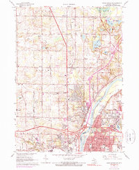
1967 Map of Cedar Springs SW
USGS Topo · Published 1973About this map
The Grand River corridor north of Grand Rapids is defined by a dense network of suburban expansion and agricultural transitions in the late 1960s. Comstock Park serves as a central hub where the Chesapeake and Ohio railroad meets the river, surrounded by established community landmarks like the Holy Trinity Ch and its namesake Holy Trinity Cem. The landscape to the north and west reveals a cluster of smaller settlements including Englishville and Ballards Corners, where early rural footprints remain visible through the Englishville Cem and various local schoolhouses like Koon Sch.
Find a feature on this map
83 named features on this map. Tap any name to fly to it.
Don’t see what you’re looking for? This feature index may not catch every label — zoom into the map to look around manually.
Map Details
Editions of this 1967 Cedar Springs SW Map
Other maps of this area

1914 · Grand Rapids
USGS Topo · 1:62,500

1918 · Cedar Springs
USGS Topo · 1:62,500

1943 · Cedar Springs
USGS Topo · 1:62,500

1943 · Grand Rapids
USGS Topo · 1:62,500

1945 · Ravenna
USGS Topo · 1:62,500

1954 · Midland
USGS Topo · 1:250,000

1958 · Midland
USGS Topo · 1:250,000

1958 · Grandville
USGS Topo · 1:62,500

1958 · Grandville
USGS Topo · 1:24,000

1958 · Grand Rapids
USGS Topo · 1:250,000
Featured Places
- Grand Rapids, MI
- Plainfield Charter Township, MI
- Walker, MI
- Alpine Township, MI
- Englishville, Alpine Township