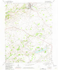
1968 Map of Cedarville
USGS Topo · Published 1981About this map
The rolling limestone country of Greene County unfolds across this survey, centered on the historic academic and agricultural hub of Cedarville. The landscape is defined by the incision of Massies Creek and its many branches, where the Penn Central rail line cuts through the terrain. To the west, the presence of Wilberforce and Cedarville College highlights the area's long-standing educational significance. A noteworthy transition is visible at Shawnee Hills, a suburban development around Shawnee Lake, contrasting with the more traditional rural patterns found near Oldtown and New Jasper. Genealogists will find considerable value in the documentation of numerous family and community burial grounds, including the Massies Creek Cem, Turnbull Cem, and the Caesar Creek Cem. Local transportation is well-recorded, from the small Port Xenia Airfield to the network of township roads like Tarbox Cemetery Road and Paintersville Road.
Find a feature on this map
54 named features on this map. Tap any name to fly to it.
Don’t see what you’re looking for? This feature index may not catch every label — zoom into the map to look around manually.
Map Details
Editions of this 1968 Cedarville Map
3 editions found
Other maps of this area

1904 · Springfield
USGS Topo · 1:62,500

1906 · Springfield
USGS Topo · 1:62,500

1907 · South Charleston
USGS Topo · 1:62,500

1916 · Octa
USGS Topo · 1:62,500

1917 · Xenia
USGS Topo · 1:62,500

1944 · Octa
USGS Topo · 1:62,500

1947 · Columbus
USGS Topo · 1:250,000

1954 · Clifton
USGS Topo · 1:24,000

1955 · New Burlington
USGS Topo · 1:24,000
1955 · Yellow Springs
USGS Topo · 1:24,000