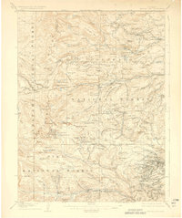
1912 Map of Central City
USGS Topo · Published 1926About this map
Central City and its surrounding mining districts dominate this 1912 survey, which covers a critical transition in the Colorado high country before the full maturation of the automobile era. The map details the intricate topography of the Continental Divide and the dense concentration of settlements like Nevadaville, Russell Gulch, and Apex that once thrived on mineral extraction. These communities are linked by the winding routes of the Colorado Southern RR and the Denver Northwestern and Pacific RR, which navigated the steep grades at Rollins Pass and Corona.
Find a feature on this map
120 named features on this map. Tap any name to fly to it.
Don’t see what you’re looking for? This feature index may not catch every label — zoom into the map to look around manually.
Map Details
Editions of this 1912 Central City Map
4 editions found
Other maps of this area

1899 · West Denver
USGS Topo · 1:125,000

1902 · Boulder
USGS Topo · 1:62,500

1903 · Georgetown
USGS Topo · 1:62,500

1904 · Boulder
USGS Topo · 1:62,500

1905 · Central City
USGS Topo · 1:62,500

1905 · Georgetown
USGS Topo · 1:62,500

1906 · Blackhawk
USGS Topo · 1:62,500

1910 · Central City
USGS Topo · 1:62,500

1912 · Central City
USGS Topo · 1:62,500

1915 · Longs Peak
USGS Topo · 1:125,000