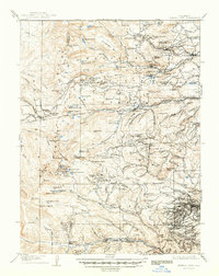
1912 Map of Central City
USGS Topo · Published 1948About this map
Central City and the surrounding gold-mining districts of Nevadaville and Apex define this industrial landscape during a period of high-altitude extraction. The map documents the intricate network of the Colorado and Southern RR and the Denver Northwestern and Pacific RR, which navigated the Continental Divide at Rollins Pass. Notable landmarks of the era's engineering include the Moffat Road, the Fawn Creek Loop, and the Riflesight Notch.
Find a feature on this map
180 named features on this map. Tap any name to fly to it.
Don’t see what you’re looking for? This feature index may not catch every label — zoom into the map to look around manually.
Map Details
Editions of this 1912 Central City Map
4 editions found
Other maps of this area

1899 · West Denver
USGS Topo · 1:125,000

1902 · Boulder
USGS Topo · 1:62,500

1903 · Georgetown
USGS Topo · 1:62,500

1904 · Boulder
USGS Topo · 1:62,500

1905 · Central City
USGS Topo · 1:62,500

1905 · Georgetown
USGS Topo · 1:62,500

1906 · Blackhawk
USGS Topo · 1:62,500

1910 · Central City
USGS Topo · 1:62,500

1912 · Central City
USGS Topo · 1:62,500

1915 · Longs Peak
USGS Topo · 1:125,000