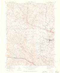
1942 Map of Central City
USGS Topo · Published 1964About this map
Central City and its surrounding mining districts appear here in 1942, reflecting decades of hard-rock extraction in the Colorado mountains. The landscape is intensely marked by the infrastructure of the late 19th and early 20th-century gold rush, from the massive open pit of The Glory Hole to the clustered settlements of Nevadaville and Russell Gulch. Higher elevations are dotted with smaller camps like Apex, Nugget, and American City, showing the extent of prospecting across Maryland Mtn and Pewabic Mtn.
Find a feature on this map
95 named features on this map. Tap any name to fly to it.
Don’t see what you’re looking for? This feature index may not catch every label — zoom into the map to look around manually.
Map Details
Editions of this 1942 Central City Map
5 editions found
Other maps of this area

1899 · West Denver
USGS Topo · 1:125,000

1903 · Georgetown
USGS Topo · 1:62,500

1905 · Central City
USGS Topo · 1:62,500

1905 · Georgetown
USGS Topo · 1:62,500

1906 · Blackhawk
USGS Topo · 1:62,500

1910 · Central City
USGS Topo · 1:62,500

1912 · Central City
USGS Topo · 1:62,500

1942 · Nederland
USGS Topo · 1:24,000

1942 · Central City
USGS Topo · 1:24,000

1942 · Tungsten
USGS Topo · 1:24,000