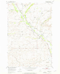
1951 Map of Chadborn
USGS Topo · Published 1976About this map
Shields River flows through the heart of the Shields Valley in this early 1950s survey, illustrating a landscape defined by extensive ranching operations and early transportation corridors. The Northern Pacific railroad line mirrors the river's course, connecting the small settlement of Chadborn and the nearby Chadbourne station to the broader region. This map is a significant resource for genealogists, as it identifies dozens of family-run operations by name, including the Keys Brothers Ranch, Schindler Ranch, and Brackett Creek Ranch.
Find a feature on this map
41 named features on this map. Tap any name to fly to it.
Don’t see what you’re looking for? This feature index may not catch every label — zoom into the map to look around manually.
Map Details
Editions of this 1951 Chadborn Map
4 editions found
Other maps of this area

1891 · Livingston
USGS Topo · 1:250,000

1893 · Livingston
USGS Topo · 1:250,000

1947 · Bozeman
USGS Topo · 1:250,000

1948 · Bozeman
USGS Topo · 1:250,000

1951 · Ibex Mountain
USGS Topo · 1:24,000

1951 · Gobblers Knob
USGS Topo · 1:24,000

1951 · Clyde Park
USGS Topo · 1:24,000

1951 · Chadborn
USGS Topo · 1:24,000

1951 · Grannis
USGS Topo · 1:24,000

1951 · Hoppers
USGS Topo · 1:24,000