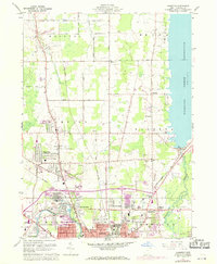
1960 Map of Champion
USGS Topo · Published 1971About this map
Industrial expansion and postwar suburban growth define the landscape between Warren and the Mosquito Creek Reservoir. The southern reaches of this survey are dominated by the rail-and-river economy of the Mahoning River valley, where the Baltimore and Ohio, Penn Central, and Erie Lackawanna railroads converge near the industrial sites of Warren and Leavittsburg. Evidence of heavy industry is clear in the Slag Pile and Sludge Pit near the river, while the growing residential footprint is visible in the development of Champion and the red-tinted urban core of the city.
Find a feature on this map
61 named features on this map. Tap any name to fly to it.
Don’t see what you’re looking for? This feature index may not catch every label — zoom into the map to look around manually.
Map Details
Editions of this 1960 Champion Map
5 editions found

Other maps of this area

1905 · Bristolville
USGS Topo · 1:62,500

1906 · Youngstown
USGS Topo · 1:62,500

1907 · Kinsman
USGS Topo · 1:62,500

1907 · Bristolville
USGS Topo · 1:62,500

1908 · Youngstown
USGS Topo · 1:62,500

1908 · Warren
USGS Topo · 1:62,500

1950 · Cleveland
USGS Topo · 1:250,000

1952 · West Farmington
USGS Topo · 1:24,000

1952 · Southington
USGS Topo · 1:24,000

1954 · Girard
USGS Topo · 1:24,000