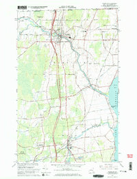
1966 Map of Champlain
USGS Topo · Published 1968About this map
The Great Chazy River flows toward its outlet in Lake Champlain during the mid-1960s, anchoring a landscape of established border towns and agricultural research. The village of Champlain sits at a critical junction where the Adirondack Northway crosses the river, while to the east, the lakeside community of Rouses Point marks the northeastern corner of the state near the United States Canada border. Local infrastructure reflects both historical roots and mid-century modernizations, from the active Delaware and Hudson railroad line to the Plattsburgh AFB Auxiliary Site. Institutional landmarks such as the William H Miner Agricultural Research Institute and several parish cemeteries, including St Patricks Cem and Sacred Heart Cem, highlight the long-standing community foundations in this region of northern Clinton County.
Find a feature on this map
61 named features on this map. Tap any name to fly to it.
Don’t see what you’re looking for? This feature index may not catch every label — zoom into the map to look around manually.
Map Details
Editions of this 1966 Champlain Map
2 editions found
Other maps of this area

1895 · Mooers
USGS Topo · 1:62,500

1895 · Rouse Point
USGS Topo · 1:62,500

1899 · Mooers
USGS Topo · 1:62,500

1907 · Rouse Point
USGS Topo · 1:62,500

1939 · Rouses Point
USGS Topo · 1:62,500

1942 · Mooers
USGS Topo · 1:62,500

1943 · Mooers
USGS Topo · 1:62,500

1943 · Rouses Point
USGS Topo · 1:62,500

1950 · Lake Champlain
USGS Topo · 1:250,000

1956 · Rouses Point
USGS Topo · 1:62,500