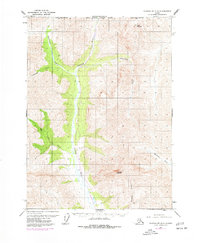
1971 Map of Chandalar D-6
USGS Topo · Published 1977About this map
The Trans-Alaska Pipeline is the industrial centerpiece of this 1970s survey, carved through the valley of the Dietrich River. Published during a pivotal era of Alaskan infrastructure development, the map documents the corridor of the pipeline as it began to reshape the Brooks Range landscape. The terrain is anchored by massive formations like Table Mountain in the north and Snowden Mountain to the south, with the North Slope Borough boundary cutting across the high ridges. Complex water systems feed into the main valley, including Kuyuktuvuk Creek and Nutirwik Creek. This edition is particularly valuable for its purple photorevisions, which capture the physical imprint of the pipeline construction efforts as they appeared mid-decade, providing a precise spatial record of one of the 20th century's most significant engineering feats.
Find a feature on this map
11 named features on this map. Tap any name to fly to it.
Don’t see what you’re looking for? This feature index may not catch every label — zoom into the map to look around manually.
Map Details
Editions of this 1971 Chandalar D-6 Map
3 editions found
Other maps of this area

1951 · Chandler Lake
USGS Topo · 1:250,000

1951 · Chandalar
USGS Topo · 1:250,000

1951 · Brooks
USGS Topo · 1:250,000

1951 · Wiseman
USGS Topo · 1:250,000

1956 · Chandalar
USGS Topo · 1:250,000

1956 · Wiseman
USGS Topo · 1:250,000

1956 · Philip Smith Mountains
USGS Topo · 1:250,000

1956 · Chandler Lake
USGS Topo · 1:250,000

1964 · Wiseman
USGS Topo · 1:250,000

1964 · Chandalar
USGS Topo · 1:250,000